Watkins, Carleton E.
The Yosemite Falls, 2634 ft.
Publisher: Watkins, Carleton E.
Subjects: Albumen Prints
Collection: United States Library of Congress: Stereoviews
Subjects: Albumen Prints
Collection: United States Library of Congress: Stereoviews
Rock studies between the Yosemite Falls.
Publisher: Watkins, Carleton E.
Subjects: Albumen Prints
Collection: United States Library of Congress: Stereoviews
Subjects: Albumen Prints
Collection: United States Library of Congress: Stereoviews
Rock studies between the Yosemite Falls.
Publisher: Watkins, Carleton E.
Subjects: Albumen Prints
Collection: United States Library of Congress: Stereoviews
Subjects: Albumen Prints
Collection: United States Library of Congress: Stereoviews
The North Dome, 3739 ft, Yosemite.
Publisher: Watkins, Carleton E.
Subjects: Albumen Prints
Collection: United States Library of Congress: Stereoviews
Subjects: Albumen Prints
Collection: United States Library of Congress: Stereoviews
Liberty Cap and the Vernal Fall, Yosemite.
Publisher: Watkins, Carleton E.
Subjects: Albumen Prints
Collection: United States Library of Congress: Stereoviews
Subjects: Albumen Prints
Collection: United States Library of Congress: Stereoviews
The Yosemite Falls from Glacier Point.
Publisher: Watkins, Carleton E.
Subjects: Albumen Prints
Collection: United States Library of Congress: Stereoviews
Subjects: Albumen Prints
Collection: United States Library of Congress: Stereoviews
El Capitan-3600 feet, mirror view, Yosemite Valley, Mariposa county, Cal.
Publisher: Watkins, Carleton E.
Subjects: Albumen Prints
Collection: United States Library of Congress: Stereoviews
Subjects: Albumen Prints
Collection: United States Library of Congress: Stereoviews
Pohono, the Bridal Veil, 900 ft., Yosemite Valley, Mariposa co., Cal.
Publisher: Watkins, Carleton E.
Subjects: Albumen Prints
Collection: United States Library of Congress: Stereoviews
Subjects: Albumen Prints
Collection: United States Library of Congress: Stereoviews
Cathedral Rocks, 2600 ft., Yosemite Valley, Mariposa co., Cal.
Publisher: Watkins, Carleton E.
Subjects: Albumen Prints
Collection: United States Library of Congress: Stereoviews
Subjects: Albumen Prints
Collection: United States Library of Congress: Stereoviews
View down the valley, from the Ferry Bend, Yosemite Valley, Mariposa co., Cal.
Publisher: Watkins, Carleton E.
Subjects: Albumen Prints
Collection: United States Library of Congress: Stereoviews
Subjects: Albumen Prints
Collection: United States Library of Congress: Stereoviews
Yosemite Valley, 2634 ft., from the Cosmopolitan Walk, Yosemite Valley, Mariposa co., Cal.
Publisher: Watkins, Carleton E.
Subjects: Albumen Prints
Collection: United States Library of Congress: Stereoviews
Subjects: Albumen Prints
Collection: United States Library of Congress: Stereoviews
Yosemite Falls, instantaneous view, Yosemite Valley, Mariposa co., Cal.
Publisher: Watkins, Carleton E.
Subjects: Albumen Prints
Collection: United States Library of Congress: Stereoviews
Subjects: Albumen Prints
Collection: United States Library of Congress: Stereoviews
Mirror view of the upper Yosemite Fall, Yosemite Valley, Mariposa co., Cal.
Publisher: Watkins, Carleton E.
Subjects: Albumen Prints
Collection: United States Library of Congress: Stereoviews
Subjects: Albumen Prints
Collection: United States Library of Congress: Stereoviews
Eagle Point, Yosemite Valley, Mariposa co., Cal.
Publisher: Watkins, Carleton E.
Subjects: Albumen Prints
Collection: United States Library of Congress: Stereoviews
Subjects: Albumen Prints
Collection: United States Library of Congress: Stereoviews
El Capitan, from the foot of the valley, Yosemite Valley, Mariposa county, Cal.
Publisher: Watkins, Carleton E.
Subjects: Albumen Prints
Collection: United States Library of Congress: Stereoviews
Subjects: Albumen Prints
Collection: United States Library of Congress: Stereoviews
The Yosemite Valley from Inspiration Point.
Publisher: Watkins, Carleton E.
Subjects: Albumen Prints
Collection: United States Library of Congress: Stereoviews
Subjects: Albumen Prints
Collection: United States Library of Congress: Stereoviews
The Yosemite Valley-view near the foot of the Valley.
Publisher: Watkins, Carleton E.
Subjects: Albumen Prints
Collection: United States Library of Congress: Stereoviews
Subjects: Albumen Prints
Collection: United States Library of Congress: Stereoviews
View up the valley from the Coulterville Road, Yosemite Valley, Mariposa co., Cal.
Publisher: Watkins, Carleton E.
Subjects: Albumen Prints
Collection: United States Library of Congress: Stereoviews
Subjects: Albumen Prints
Collection: United States Library of Congress: Stereoviews
Cathedral Rock, 2000 feet, Yosemite Valley, Mariposa County, Cal.
Publisher: Watkins, Carleton E.
Subjects: Yosemite Valley (Calif.), Albumen Prints
Collection: United States Library of Congress: Stereoviews
Subjects: Yosemite Valley (Calif.), Albumen Prints
Collection: United States Library of Congress: Stereoviews
The Domes, Yosemite Valley, Mariposa County, Cal.
Publisher: Watkins, Carleton E.
Subjects: Yosemite Valley (Calif.), Albumen Prints
Collection: United States Library of Congress: Stereoviews
Subjects: Yosemite Valley (Calif.), Albumen Prints
Collection: United States Library of Congress: Stereoviews
Yosemite Falls, from the Sentinel Dome, Yosemite Valley, Mariposa Co.
Publisher: Watkins, Carleton E.
Subjects: Yosemite Valley (Calif.), Albumen Prints
Collection: United States Library of Congress: Stereoviews
Subjects: Yosemite Valley (Calif.), Albumen Prints
Collection: United States Library of Congress: Stereoviews
The Vernal and Nevada Fall, f[rom] Glacier Point, Yosemite Valley, Mariposa County, Cal.
Publisher: Watkins, Carleton E.
Subjects: Yosemite Valley (Calif.), Albumen Prints
Collection: United States Library of Congress: Stereoviews
Subjects: Yosemite Valley (Calif.), Albumen Prints
Collection: United States Library of Congress: Stereoviews
The Sentinel, 3270 feet, Yosemite Valley, Mariposa County, Cal.
Publisher: Watkins, Carleton E.
Subjects: Yosemite Valley (Calif.), Albumen Prints
Collection: United States Library of Congress: Stereoviews
Subjects: Yosemite Valley (Calif.), Albumen Prints
Collection: United States Library of Congress: Stereoviews
North Dome, Royal Arches, and Washington Column, Yosemite Valley, Mariposa County, Cal.
Publisher: Watkins, Carleton E.
Subjects: Yosemite Valley (Calif.), Albumen Prints
Collection: United States Library of Congress: Stereoviews
Subjects: Yosemite Valley (Calif.), Albumen Prints
Collection: United States Library of Congress: Stereoviews
Yowiye, or the Nevada Fall, and Mt. Broderick, Yosemite Valley, Mariposa County, Cal.
Publisher: Watkins, Carleton E.
Subjects: Yosemite Valley (Calif.), Albumen Prints
Collection: United States Library of Congress: Stereoviews
Subjects: Yosemite Valley (Calif.), Albumen Prints
Collection: United States Library of Congress: Stereoviews
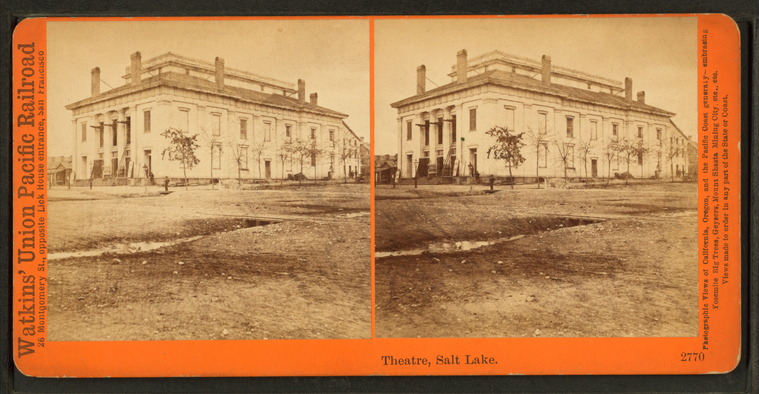
Theatre, Salt Lake.
Publisher: Watkins, Carleton E.
Photographer: Watkins, Carleton E. (1829-1916)
Collection: NYPL Digital Collections: Robert N. Dennis [From The New York Public Library]
Photographer: Watkins, Carleton E. (1829-1916)
Collection: NYPL Digital Collections: Robert N. Dennis [From The New York Public Library]
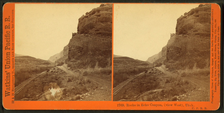
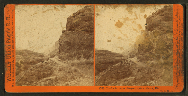
Rocks in Echo Canyon, (view west), Utah. U.P.R.R.
Publisher: Watkins, Carleton E.
Photographer: Watkins, Carleton E. (1829-1916)
Collection: NYPL Digital Collections: Robert N. Dennis [From The New York Public Library]
Photographer: Watkins, Carleton E. (1829-1916)
Collection: NYPL Digital Collections: Robert N. Dennis [From The New York Public Library]
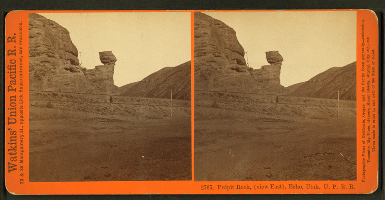
Pulpit Rock, (view east), Echo, Utah. U.P.R.R.
Publisher: Watkins, Carleton E.
Photographer: Watkins, Carleton E. (1829-1916)
Collection: NYPL Digital Collections: Robert N. Dennis [From The New York Public Library]
Photographer: Watkins, Carleton E. (1829-1916)
Collection: NYPL Digital Collections: Robert N. Dennis [From The New York Public Library]
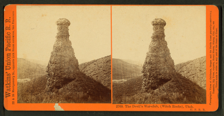
The Devil's War-club, (Witch Rocks), Utah. U.P.R.R.
Publisher: Watkins, Carleton E.
Photographer: Watkins, Carleton E. (1829-1916)
Collection: NYPL Digital Collections: Robert N. Dennis [From The New York Public Library]
Photographer: Watkins, Carleton E. (1829-1916)
Collection: NYPL Digital Collections: Robert N. Dennis [From The New York Public Library]


![The Vernal and Nevada Fall, f[rom] Glacier Point, Yosemite Valley, Mariposa County, Cal. Stereoview Card](https://cdn.loc.gov/service/pnp/stereo/1s00000/1s01000/1s01100/1s01137v.jpg#h=518&w=1024)


